


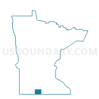
Fraser Twp. Voting District, Martin County, Minnesota
About
Outline

Summary
| Unique Area Identifier | 603110 |
| Name | Fraser Twp. Voting District |
| County | Martin County |
| State | Minnesota |
| Area (square miles) | 36.61 |
| Land Area (square miles) | 36.37 |
| Water Area (square miles) | 0.24 |
| % of Land Area | 99.35 |
| % of Water Area | 0.65 |
| Latitude of the Internal Point | 43.72070930 |
| Longtitude of the Internal Point | -94.56217440 |
Maps


Graphs
Select a template below for downloading or customizing gragh for Fraser Twp. Voting District, Martin County, Minnesota


Neighbors
Neighoring Voting District (by Name) Neighboring Voting District on the Map
- Fairmont W-4 P-1, Martin County, MN
- Fox Lake Twp. Voting District, Martin County, MN
- Galena Twp. Voting District, Martin County, MN
- Rolling Green Twp. Voting District, Martin County, MN
- Rutland Twp. Voting District, Martin County, MN
- Waverly Twp. Voting District, Martin County, MN
- Welcome Voting District, Martin County, MN
- Westford Twp. Voting District, Martin County, MN
Top 10 Neighboring County Subdivision (by Population) Neighboring County Subdivision on the Map
- Fairmont city, Martin County, MN (10,666)
- Welcome city, Martin County, MN (686)
- Rutland township, Martin County, MN (437)
- Fraser township, Martin County, MN (304)
- Westford township, Martin County, MN (295)
- Rolling Green township, Martin County, MN (266)
- Fox Lake township, Martin County, MN (256)
- Galena township, Martin County, MN (248)
- Waverly township, Martin County, MN (208)
Top 10 Neighboring Place (by Population) Neighboring Place on the Map
Top 10 Neighboring Unified School District (by Population) Neighboring Unified School District on the Map
- Fairmont Area School District, MN (12,890)
- Martin County West Public School District, MN (4,520)
- Truman Public School District, MN (2,374)
Top 10 Neighboring State Legislative District Lower Chamber (by Population) Neighboring State Legislative District Lower Chamber on the Map
Top 10 Neighboring State Legislative District Upper Chamber (by Population) Neighboring State Legislative District Upper Chamber on the Map
Top 10 Neighboring 111th Congressional District (by Population) Neighboring 111th Congressional District on the Map
Top 10 Neighboring Census Tract (by Population) Neighboring Census Tract on the Map
- Census Tract 7906, Martin County, MN (4,359)
- Census Tract 7901, Martin County, MN (3,108)
- Census Tract 7902, Martin County, MN (2,587)
- Census Tract 7903, Martin County, MN (2,430)